

tigris is an R package that allows users to directly download and use TIGER/Line shapefiles (https://www.census.gov/geo/maps-data/data/tiger-line.html) from the US Census Bureau.
To install the package from CRAN, issue the following command in R:
install.packages('tigris')Or, get the development version from GitHub:
devtools::install_github('walkerke/tigris')As of version 1.0 (released in July 2020), tigris functions return simple features objects with a default year of 2019. To get started, choose a function from the table below and use it with a state and/or county if required. You’ll get back an sf object for use in your mapping and spatial analysis projects:
library(tigris)
library(ggplot2)

manhattan_roads <- roads("NY", "New York")

ggplot(manhattan_roads) +
  geom_sf() +
  theme_void()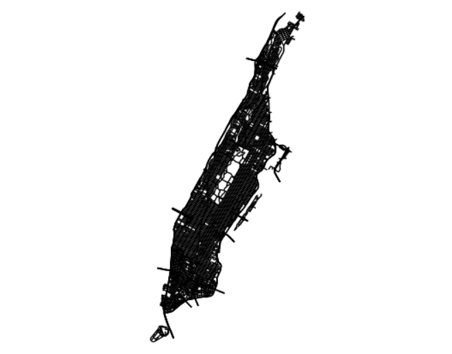
tigris only returns feature geometries for US Census data which default to the coordinate reference system NAD 1983 (EPSG: 4269). For US Census demographic data (optionally pre-joined to tigris geometries), try the tidycensus package. For help deciding on an appropriate coordinate reference system for your project, take a look at the crsuggest package.
Updated documentation for tigris is coming later this year in the book Analyzing the US Census with R. In the meantime, I’d recommend the following materials to learn about conceptual foundations of the package:
Available datasets:
Please note: cartographic boundary files in tigris are not available for 2011 and 2012.
| Function | Datasets available | Years available |
|---|---|---|
| nation() | cartographic (1:5m; 1:20m) | 2013-2019 |
| divisions() | cartographic (1:500k; 1:5m; 1:20m) | 2013-2019 |
| regions() | cartographic (1:500k; 1:5m; 1:20m) | 2013-2019 |
| states() | TIGER/Line; cartographic (1:500k; 1:5m; 1:20m) | 1990, 2000, 2010-2019 |
| counties() | TIGER/Line; cartographic (1:500k; 1:5m; 1:20m) | 1990, 2000, 2010-2019 |
| tracts() | TIGER/Line; cartographic (1:500k) | 1990, 2000, 2010-2019 |
| block_groups() | TIGER/Line; cartographic (1:500k) | 1990, 2000, 2010-2019 |
| blocks() | TIGER/Line | 2000, 2010-2019 |
| places() | TIGER/Line; cartographic (1:500k) | 2011-2019 |
| pumas() | TIGER/Line; cartographic (1:500k) | 2012-2019 |
| school_districts() | TIGER/Line; cartographic | 2011-2019 |
| zctas() | TIGER/Line; cartographic (1:500k) | 2000, 2010, 2012-2019 |
| congressional_districts() | TIGER/Line; cartographic (1:500k; 1:5m; 1:20m) | 2011-2019 |
| state_legislative_districts() | TIGER/Line; cartographic (1:500k) | 2011-2019 |
| voting_districts() | TIGER/Line | 2012 |
| area_water() | TIGER/Line | 2011-2019 |
| linear_water() | TIGER/Line | 2011-2019 |
| coastline | TIGER/Line() | 2013-2019 |
| core_based_statistical_areas() | TIGER/Line; cartographic (1:500k; 1:5m; 1:20m) | 2011-2019 |
| combined_statistical_areas() | TIGER/Line; cartographic (1:500k; 1:5m; 1:20m) | 2011-2019 |
| metro_divisions() | TIGER/Line | 2011-2019 |
| new_england() | TIGER/Line; cartographic (1:500k) | 2011-2019 |
| county_subdivisions() | TIGER/Line; cartographic (1:500k) | 2010-2019 |
| urban_areas() | TIGER/Line; cartographic (1:500k) | 2012-2019 |
| primary_roads() | TIGER/Line | 2011-2019 |
| primary_secondary_roads() | TIGER/Line | 2011-2019 |
| roads() | TIGER/Line | 2011-2019 |
| rails() | TIGER/Line | 2011-2019 |
| native_areas() | TIGER/Line; cartographic (1:500k) | 2011-2019 |
| alaska_native_regional_corporations() | TIGER/Line; cartographic (1:500k) | 2011-2019 |
| tribal_block_groups() | TIGER/Line | 2011-2019 |
| tribal_census_tracts() | TIGER/Line | 2011-2019 |
| tribal_subdivisions_national() | TIGER/Line | 2011-2019 |
| landmarks() | TIGER/Line | 2011-2019 |
| military() | TIGER/Line | 2011-2019 |