

![]()
Convert various data formats to GeoJSON or TopoJSON
This package is a utility to convert geographic data to GeoJSON and TopoJSON formats. Nothing else. We hope to do this one job very well, and handle all reasonable use cases.
Functions in this package are organized first around what you’re working with or want to get, GeoJSON or TopoJSON, then convert to or read from various formats:
geojson_list()/topojson_list() - convert to GeoJSON/TopoJSON as R list formatgeojson_json()/topojson_json() - convert to GeoJSON/TopoJSON as JSONgeojson_sp() - convert output of geojson_list() or geojson_json() to sp spatial objectsgeojson_sf() - convert output of geojson_list() or geojson_json() to sf objectsgeojson_read()/topojson_read() - read a GeoJSON/TopoJSON file from file path or URLgeojson_write()/topojson_write() - write a GeoJSON/TopoJSON file locallyEach of the above functions have methods for various objects/classes, including numeric, data.frame, list, SpatialPolygons, SpatialLines, SpatialPoints, etc.
Additional functions:
map_gist() - push up a GeoJSON or topojson file as a GitHub gist (renders as an interactive map)map_leaf() - create a local interactive map using the leaflet packageA note about installing rgeos - built on top of C libraries, and installation often causes trouble for Linux users because no binaries are provided on CRAN for those platforms. Other dependencies in geojsonio should install easily automatically when you install geojsonio.
Mac
Install GDAL on the command line first, e.g., using homebrew
brew install gdalThen install rgeos
Linux
Get deps first
sudo apt-get install libgdal1-dev libgdal-dev libgeos-c1 libproj-devNote: if you have trouble installing rgeos, try installing
libgeos++-dev
Then install rgeos
Install geojsonio
Stable version from CRAN
Or development version from GitHub
From a numeric vector of length 2, as json or list
geojson_json(c(32.45, -99.74))
#> <FeatureCollection>
#>   type:  FeatureCollection
#>   no. features:  1
#> features (1st 5): Pointgeojson_list(c(32.45, -99.74))
#> $type
#> [1] "FeatureCollection"
#>
#> $features
#> $features[[1]]
#> $features[[1]]$type
#> [1] "Feature"
#>
#> $features[[1]]$geometry
#> $features[[1]]$geometry$type
...From a data.frame
library('maps')
data(us.cities)
geojson_json(us.cities[1:2, ], lat = 'lat', lon = 'long')
#> <FeatureCollection>
#>   type:  FeatureCollection
#>   no. features:  2
#> features (1st 5): Point, Pointgeojson_list(us.cities[1:2, ], lat = 'lat', lon = 'long')
#> $type
#> [1] "FeatureCollection"
#>
#> $features
#> $features[[1]]
#> $features[[1]]$type
#> [1] "Feature"
#>
#> $features[[1]]$geometry
#> $features[[1]]$geometry$type
...From SpatialPolygons class
library('sp')
poly1 <- Polygons(list(Polygon(cbind(c(-100, -90, -85, -100),
  c(40, 50, 45, 40)))), "1")
poly2 <- Polygons(list(Polygon(cbind(c(-90, -80, -75, -90),
  c(30, 40, 35, 30)))), "2")
sp_poly <- SpatialPolygons(list(poly1, poly2), 1:2)
to json
geojson_json(sp_poly)
#> <FeatureCollection>
#>   type:  FeatureCollection
#>   no. features:  2
#>   features (1st 5):  Polygon, Polygon
to list
geojson_list(sp_poly)$features[[1]]
#> $type
#> [1] "Feature"
#>
#> $id
#> [1] 1
#>
#> $properties
#> $properties$dummy
#> [1] 0
#>
...geo_list + geo_list
Note:
geo_listis the output type fromgeojson_list(), it’s just a list with a class attached so we know it’s geojson :)
vec <- c(-99.74, 32.45)
a <- geojson_list(vec)
vecs <- list(c(100.0, 0.0), c(101.0, 0.0), c(100.0, 0.0))
b <- geojson_list(vecs, geometry = "polygon")
a + b
#> $type
#> [1] "FeatureCollection"
#>
#> $features
#> $features[[1]]
#> $features[[1]]$type
#> [1] "Feature"
#>
#> $features[[1]]$geometry
#> $features[[1]]$geometry$type
...
json + json
c <- geojson_json(c(-99.74, 32.45))
vecs <- list(c(100.0, 0.0), c(101.0, 0.0), c(101.0, 1.0), c(100.0, 1.0), c(100.0, 0.0))
d <- geojson_json(vecs, geometry = "polygon")
c + d
#> {"type":"FeatureCollection","features":[{"type":"Feature","geometry":{"type":"Point","coordinates":[-99.74,32.45]},"properties":{}},{"type":"Feature","geometry":{"type":"Polygon","coordinates":[[[100,0],[101,0],[101,1],[100,1],[100,0]]]},"properties":[]}]}library('maps')
data(us.cities)
geojson_write(us.cities[1:2, ], lat = 'lat', lon = 'long')
#> <geojson-file>
#> Path: myfile.geojson
#> From class: data.framefile <- system.file("examples", "california.geojson", package = "geojsonio")
out <- geojson_read(file)
names(out)
#> [1] "type" "name" "crs" "features"
names(out$features[[1]])
#> [1] "type" "properties" "geometry"topojson_json(c(-99.74,32.45))
#> {"type":"Topology","objects":{"foo":{"type":"GeometryCollection","geometries":[{"type":"Point","coordinates":[-99.74,32.45]}]}},"arcs":[],"bbox":[-99.74,32.45,-99.74,32.45]}library(sp)
x <- c(1,2,3,4,5)
y <- c(3,2,5,1,4)
s <- SpatialPoints(cbind(x,y))
topojson_list(s)
#> $type
#> [1] "Topology"
#>
#> $objects
#> $objects$foo
#> $objects$foo$type
#> [1] "GeometryCollection"
#>
#> $objects$foo$geometries
#> $objects$foo$geometries[[1]]
#> $objects$foo$geometries[[1]]$type
#> [1] "Point"
#>
#> $objects$foo$geometries[[1]]$coordinates
#> [1] 1 3
#>
#> $objects$foo$geometries[[1]]$id
#> [1] 1
#>
#> $objects$foo$geometries[[1]]$properties
...library('maps')
data(us.cities)
topojson_write(us.cities[1:2, ], lat = 'lat', lon = 'long')
#> <topojson-file>
#> Path: myfile.topojson
#> From class: data.framefile <- system.file("examples", "us_states.topojson", package = "geojsonio")
out <- topojson_read(file)
#> Reading layer `states' from data source `/Library/Frameworks/R.framework/Versions/3.6/Resources/library/geojsonio/examples/us_states.topojson' using driver `TopoJSON'
#> Simple feature collection with 51 features and 1 field
#> geometry type: MULTIPOLYGON
#> dimension: XY
#> bbox: xmin: -171.7911 ymin: 18.91619 xmax: -66.96466 ymax: 71.35776
#> epsg (SRID): NA
#> proj4string: NA
plot(out)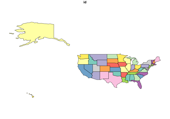
Using data from https://github.com/glynnbird/usstatesgeojson
Get some geojson
library('crul')
res <- HttpClient$new('https://api.github.com')$get('repos/glynnbird/usstatesgeojson/contents')
out <- jsonlite::fromJSON(res$parse("UTF-8"), FALSE)
st_names <- Filter(function(x) grepl("\\.geojson", x), sapply(out, "[[", "name"))
base <- 'https://raw.githubusercontent.com/glynnbird/usstatesgeojson/master/'
st_files <- paste0(base, st_names)
Make a faceted plot
library('ggplot2')
library('plyr')
st_use <- st_files[7:13]
geo <- lapply(st_use, geojson_read, what = "sp")
df <- ldply(setNames(lapply(geo, fortify), gsub("\\.geojson", "", st_names[7:13])))
ggplot(df, aes(long, lat, group = group)) +
  geom_polygon() +
  facet_wrap(~.id, scales = "free")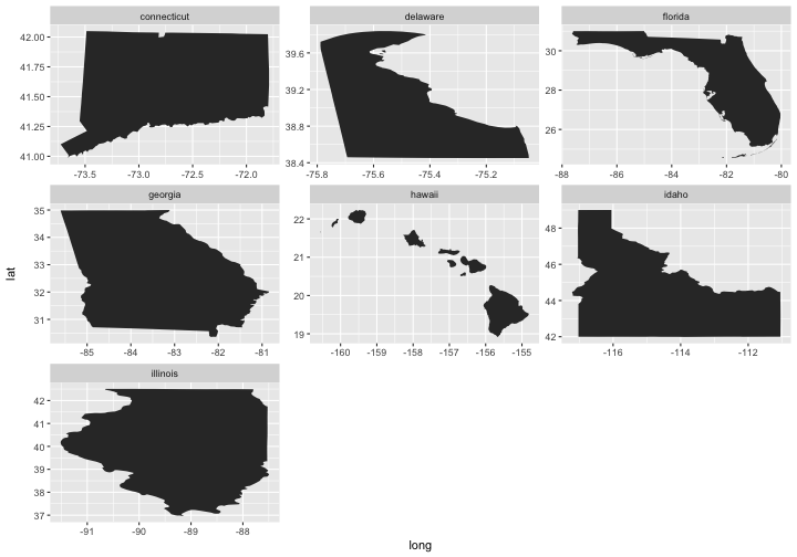
Okay, so the maps are not quite right (stretched to fit each panel), but you get the idea.
geo2topo() and topo2geo()
x <- '{"type": "LineString", "coordinates": [ [100.0, 0.0], [101.0, 1.0] ]}'
(topo_json <- geo2topo(x))
#> {"type":"Topology","objects":{"foo":{"type":"LineString","arcs":[0]}},"arcs":[[[100,0],[101,1]]],"bbox":[100,0,101,1]}
topo2geo(topo_json)
#> <FeatureCollection>
#>   type:  FeatureCollection
#>   no. features:  1
#> features (1st 5): LineStringgeojsonio in R doing citation(package = 'geojsonio')