
Authors: Andrew Plowright
License: GPL 3
This package provides tools for working with tiled geospatial datasets.
Use the tileScheme function to create a set of tiles from a Raster or Extent object.
library(TileManager)
#> TileManager - Please note that version 0.4.0 is NOT backwards compatible

data(CHMdemo)

ts <- tileScheme(CHMdemo, tiledim = c(30,30), buffer = 5)

plot(CHMdemo)
plot(ts, add = T)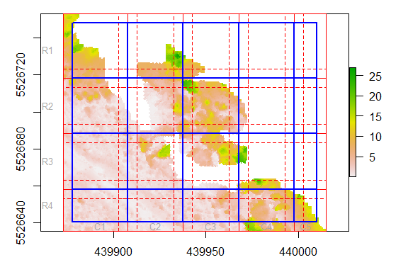
Use the removeEmpty argument to drop tiles with no Raster values.
ts <- tileScheme(CHMdemo, tiledim = c(20,20), buffer = 2.5, removeEmpty = TRUE)

plot(CHMdemo)
plot(ts, add = T)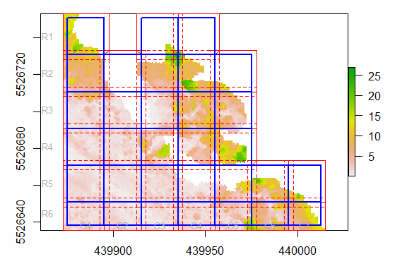
Other handy features:
origin argument can be used to force the tile scheme to snap to a pair of coordinates.bufferSpill argument controls whether or not the buffers extent beyond the input’s original extent.cells argument, they can be defined by a number of Raster cells.A ‘tileScheme’ object is composed of the following slots:
str(ts, 2)
#> Formal class 'tileScheme' [package "TileManager"] with 6 slots
#>   ..@ tiles :List of 32
#>   ..@ buffs :List of 32
#>   ..@ nbuffs:List of 32
#>   ..@ crs   :Formal class 'CRS' [package "sp"] with 1 slot
#>   ..@ buffer: num 2.5
#> ..@ data :'data.frame': 32 obs. of 3 variables:tiles: the actual extents of the tilesbuffs: the buffered tilesnbuffs: the non-overlapping buffers (see section below)crs slot, which stores the tile scheme’s coordinate reference system.buffer slot.data slot, which stores the row, column and name of each tile.head(ts@data)
#> row col tileName
#> R1C1 1 1 R1C1
#> R1C3 1 3 R1C3
#> R1C4 1 4 R1C4
#> R2C1 2 1 R2C1
#> R2C2 2 2 R2C2
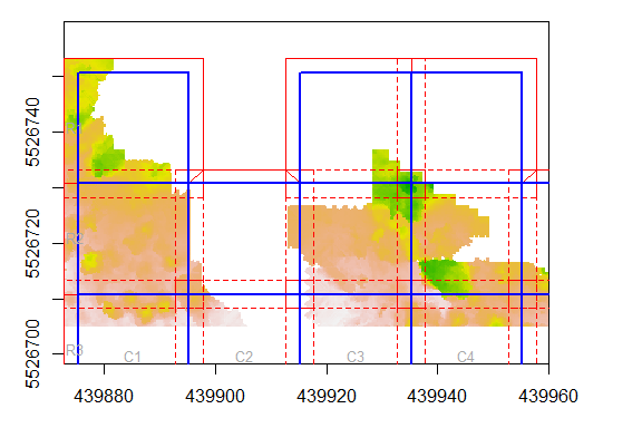
#> R2C3 2 3 R2C3Non-overlapping buffers (often abbreviated to nbuffs) are useful for re-assembling tiled data. Essentially, they preserve buffers only where they do not overlap onto neighboring tiles (i.e.: along the edge of the tile scheme). This allows you to recombine tiles without worrying about overlapping areas and without losing any information along the data edges.
In the example below:
Some useful methods are provided for subsetting the tile scheme, or for converting it into other formats.
Get buffers as a SpatialPolygonsDataFrame:
ts[["buffs"]]
#> class       : SpatialPolygonsDataFrame
#> features    : 32
#> extent      : 439872.8, 440015.2, 5526636, 5526753  (xmin, xmax, ymin, ymax)
#> crs         : +proj=utm +zone=11 +datum=WGS84 +units=m +no_defs +ellps=WGS84 +towgs84=0,0,0
#> variables   : 3
#> names       : row, col, tileName
#> min values  :   1,   1,     R1C1
#> max values  :   6,   7,     R6C7
Subset a specific tile by name, number or row/col:
# By name
ts["R2C2"]
#> class     : tileScheme
#> extent    : 439895.25, 439915.25, 5526710.75, 5526730.75 (xmin, xmax, ymin, ymax)
#> CRS       : +proj=utm +zone=11 +datum=WGS84 +units=m +no_defs +ellps=WGS84 +towgs84=0,0,0
#> tiles     : 1
#> nrow/ncol : 1,1
#> buffer    : 2.5
#> variables : row, col, tileName

# By number
ts[7]
#> class     : tileScheme
#> extent    : 439935.25, 439955.25, 5526710.75, 5526730.75 (xmin, xmax, ymin, ymax)
#> CRS       : +proj=utm +zone=11 +datum=WGS84 +units=m +no_defs +ellps=WGS84 +towgs84=0,0,0
#> tiles     : 1
#> nrow/ncol : 1,1
#> buffer    : 2.5
#> variables : row, col, tileName

# By row/col
ts[2,3]
#> class     : tileScheme
#> extent    : 439915.25, 439935.25, 5526710.75, 5526730.75 (xmin, xmax, ymin, ymax)
#> CRS       : +proj=utm +zone=11 +datum=WGS84 +units=m +no_defs +ellps=WGS84 +towgs84=0,0,0
#> tiles     : 1
#> nrow/ncol : 1,1
#> buffer    : 2.5
#> variables : row, col, tileName
Subset entire rows or columns:
# One row
ts[4,]
#> class     : tileScheme
#> extent    : 439875.25, 439975.25, 5526670.75, 5526690.75 (xmin, xmax, ymin, ymax)
#> CRS       : +proj=utm +zone=11 +datum=WGS84 +units=m +no_defs +ellps=WGS84 +towgs84=0,0,0
#> tiles     : 5
#> nrow/ncol : 1,5
#> buffer    : 2.5
#> variables : row, col, tileName

# Multiple columns
ts[,2:3]
#> class     : tileScheme
#> extent    : 439895.25, 439935.25, 5526638, 5526750.75 (xmin, xmax, ymin, ymax)
#> CRS       : +proj=utm +zone=11 +datum=WGS84 +units=m +no_defs +ellps=WGS84 +towgs84=0,0,0
#> tiles     : 11
#> nrow/ncol : 6,2
#> buffer    : 2.5
#> variables : row, col, tileNameThe tile scheme can be saved as a single SHP file. In this case, tiles, buffs and nbuffs will all be merged into a single polygons dataset. Buffer information is saved to an accompanying XML file.
# Create tile scheme
ts <- tileScheme(CHMdemo, tiledim = c(30,30), buffer = 5)

# Save tile scheme
tileSave(ts, "C:/myfiles/tilescheme.shp")

# Load tile scheme
ts <- tileLoad("C:/myfiles/tilescheme.shp")If you have a received a series of tiled raster files, the tileDetector function can even be used to detect the tile size and buffer size of the data and generate the associated tileScheme.