The MEDITS packages was realized to work with survey data in the format of the MEDITS project. The package uses TA-, TB-, and TC-like tables. Functions using TE and TL table are not already implemented. TA table contains hauls’ information; TB contains catch data; TC contains aggregated biological data. Examples of TA, TB and TC table were added to the package in order to execute the example codes.
You can install the released version of MEDITS from CRAN with:
The MEDITS format uses a specific format for the geographic coordinates. Two functions were introduced to convert the coordinates respectively from the MEDITs format to decimal degrees format and viceversa.
# Coordinates conversion from MEDITS format to decimal degrees
library(MEDITS)
dd <- MEDITS.to.dd(TA)
head(dd)
#> TYPE_OF_FILE COUNTRY AREA VESSEL GEAR RIGGING DOORS YEAR MONTH DAY
#> 1 TA ITA 10 PEC GOC73 GC73 WHS8 2007 8 11
#> 2 TA ITA 10 PEC GOC73 GC73 WHS8 2007 8 11
#> 3 TA ITA 10 PEC GOC73 GC73 WHS8 2007 8 11
#> 4 TA ITA 10 PEC GOC73 GC73 WHS8 2007 8 11
#> 5 TA ITA 10 PEC GOC73 GC73 WHS8 2007 8 11
#> 6 TA ITA 10 PEC GOC73 GC73 WHS8 2007 8 11
#> HAUL_NUMBER CODEND_CLOSING PART_OF_THE_CODEND SHOOTING_TIME
#> 1 1 S S 1114
#> 2 2 S S 948
#> 3 3 S S 1500
#> 4 4 S S 1355
#> 5 5 S S 502
#> 6 6 S S 615
#> SHOOTING_QUADRANT SHOOTING_LATITUDE SHOOTING_LONGITUDE SHOOTING_DEPTH
#> 1 1 40.96233 13.66683 376
#> 2 1 41.03167 13.69167 109
#> 3 1 40.90900 13.82950 113
#> 4 1 40.95750 13.78783 95
#> 5 1 40.81617 13.96200 77
#> 6 1 40.91733 13.93683 25
#> HAULING_TIME HAULING_QUADRANT HAULING_LATITUDE HAULING_LONGITUDE
#> 1 1214 1 40.92067 13.70017
#> 2 1018 1 41.01117 13.70483
#> 3 1530 1 40.88800 13.85900
#> 4 1425 1 40.94050 13.80650
#> 5 532 1 40.83967 13.95783
#> 6 645 1 40.90317 13.91733
#> HAULING_DEPTH HAUL_DURATION VALIDITY COURSE RECORDED_SPECIES DISTANCE
#> 1 331 60 V R 3 5500
#> 2 112 30 V R 3 2593
#> 3 119 30 V R 3 2926
#> 4 97 30 V R 3 2500
#> 5 75 30 V R 3 2759
#> 6 23 30 V R 3 2630
#> VERTICAL_OPENING WING_OPENING GEOMETRICAL_PRECISION BRIDLES_LENGTH
#> 1 19 191 E 150
#> 2 19 182 E 100
#> 3 19 182 E 100
#> 4 19 182 E 100
#> 5 19 182 E 100
#> 6 19 163 E 100
#> WARP_LENGTH WARP_DIAMETER HYDROLOGICAL_STATION OBSERVATIONS
#> 1 1300 14 0 0
#> 2 550 14 0 0
#> 3 550 14 0 0
#> 4 550 14 0 0
#> 5 450 14 0 0
#> 6 300 14 0 0
#> BOTTOM_TEMPERATURE_BEGINNING BOTTOM_TEMPERATURE_END MEASURING_SYSTEM
#> 1 14.0 14.0 VA
#> 2 14.3 14.2 VA
#> 3 14.3 14.0 VA
#> 4 14.6 14.3 VA
#> 5 14.9 14.9 VA
#> 6 18.1 18.6 VA
#> NUMBER_OF_THE_STRATUM BOTTOM_SALINITY_BEGINNING BOTTOM_SALINITY_END
#> 1 13404 NA NA
#> 2 13403 NA NA
#> 3 13403 NA NA
#> 4 13402 NA NA
#> 5 13402 NA NA
#> 6 13401 NA NA
#> MEASURING_SYSTEM_SALINITY
#> 1 NA
#> 2 NA
#> 3 NA
#> 4 NA
#> 5 NA
#> 6 NA
# Coordinates conversion from decimal degrees to MEDITS format
med <- dd.to.MEDITS(dd)
head(med)
#> TYPE_OF_FILE COUNTRY AREA VESSEL GEAR RIGGING DOORS YEAR MONTH DAY
#> 1 TA ITA 10 PEC GOC73 GC73 WHS8 2007 8 11
#> 2 TA ITA 10 PEC GOC73 GC73 WHS8 2007 8 11
#> 3 TA ITA 10 PEC GOC73 GC73 WHS8 2007 8 11
#> 4 TA ITA 10 PEC GOC73 GC73 WHS8 2007 8 11
#> 5 TA ITA 10 PEC GOC73 GC73 WHS8 2007 8 11
#> 6 TA ITA 10 PEC GOC73 GC73 WHS8 2007 8 11
#> HAUL_NUMBER CODEND_CLOSING PART_OF_THE_CODEND SHOOTING_TIME
#> 1 1 S S 1114
#> 2 2 S S 948
#> 3 3 S S 1500
#> 4 4 S S 1355
#> 5 5 S S 502
#> 6 6 S S 615
#> SHOOTING_QUADRANT SHOOTING_LATITUDE SHOOTING_LONGITUDE SHOOTING_DEPTH
#> 1 1 4057.74 1340.01 376
#> 2 1 4101.90 1341.50 109
#> 3 1 4054.54 1349.77 113
#> 4 1 4057.45 1347.27 95
#> 5 1 4048.97 1357.72 77
#> 6 1 4055.04 1356.21 25
#> HAULING_TIME HAULING_QUADRANT HAULING_LATITUDE HAULING_LONGITUDE
#> 1 1214 1 4055.24 1342.01
#> 2 1018 1 4100.67 1342.29
#> 3 1530 1 4053.28 1351.54
#> 4 1425 1 4056.43 1348.39
#> 5 532 1 4050.38 1357.47
#> 6 645 1 4054.19 1355.04
#> HAULING_DEPTH HAUL_DURATION VALIDITY COURSE RECORDED_SPECIES DISTANCE
#> 1 331 60 V R 3 5500
#> 2 112 30 V R 3 2593
#> 3 119 30 V R 3 2926
#> 4 97 30 V R 3 2500
#> 5 75 30 V R 3 2759
#> 6 23 30 V R 3 2630
#> VERTICAL_OPENING WING_OPENING GEOMETRICAL_PRECISION BRIDLES_LENGTH
#> 1 19 191 E 150
#> 2 19 182 E 100
#> 3 19 182 E 100
#> 4 19 182 E 100
#> 5 19 182 E 100
#> 6 19 163 E 100
#> WARP_LENGTH WARP_DIAMETER HYDROLOGICAL_STATION OBSERVATIONS
#> 1 1300 14 0 0
#> 2 550 14 0 0
#> 3 550 14 0 0
#> 4 550 14 0 0
#> 5 450 14 0 0
#> 6 300 14 0 0
#> BOTTOM_TEMPERATURE_BEGINNING BOTTOM_TEMPERATURE_END MEASURING_SYSTEM
#> 1 14.0 14.0 VA
#> 2 14.3 14.2 VA
#> 3 14.3 14.0 VA
#> 4 14.6 14.3 VA
#> 5 14.9 14.9 VA
#> 6 18.1 18.6 VA
#> NUMBER_OF_THE_STRATUM BOTTOM_SALINITY_BEGINNING BOTTOM_SALINITY_END
#> 1 13404 NA NA
#> 2 13403 NA NA
#> 3 13403 NA NA
#> 4 13402 NA NA
#> 5 13402 NA NA
#> 6 13401 NA NA
#> MEASURING_SYSTEM_SALINITY
#> 1 NA
#> 2 NA
#> 3 NA
#> 4 NA
#> 5 NA
#> 6 NATwo functions were also introduced to estimate the hauls distance using respectivelly MEDITS coordinates and decimal degrees coordinates:
library(MEDITS)
# distance estimation using MEDITS coordinates
med.dist <- MEDITS.distance(TA, unit="km", verbose=TRUE)
#> kilometers
head(med.dist)
#> [1] 5.409739 2.531317 3.403627 2.454159 2.634717 2.271499

# distance estimation using decimal degrees coordinates
dd <- MEDITS.to.dd(TA)
dd.dist <- dd.distance(dd, unit="km", verbose=TRUE)
#> kilometers
head(dd.dist)
#> [1] 5.409739 2.531317 3.403627 2.454159 2.634717 2.271499
The function land.points allows to check whether some of the TA table’s coordinates fall on the land:
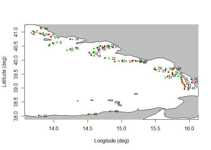
A plot of haul’s positions could also be generated, with the possibility to define the years range to be considered, the GSA area and, whether both initial and end coordinates should be plotted or only the mean haul coordinates:

To link the geographic information of the hauls respectively to catch and biological data were introduced two different functions: m.TATB and m.TATC:
# merge of TA and TB tables
mTATB <- m.TATB(TA,TB,"ARISFOL")

# merge of TA and TB tables
mTATC <- m.TATC(TA,TC,"ARISFOL")
The estimation of the indices’ time series is performed by the index.ts function. It is possible to estimate the following indices: abundance, inverse of abundance CV, biomass and mean individual weight (MIW). The analysis could also be performed by sex.
merge_TATB <- m.TATB(TA,TB,"ARISFOL")
ind <- index.ts(merge_TATB, index="abundance", depth_range = c(500,800), sex="f",
str.scheme=strata_scheme, surf=stratification_scheme)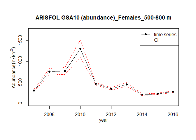
The function sexratio.ts estimates the time series of the sex ratio:
ind <- m.TATB(TA,TB,"ARISFOL")
sexratio.ts(merge = ind, GSA = NA, sspp = NA, depth_range=c(500,800),
strata_scheme=strata_scheme, stratification=stratification_scheme, plot=TRUE )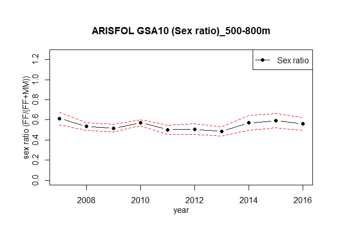
#>    year Indices_F Indices_FM sex.ratio     variance         sd
#> 1  2007  299.2558   486.8133 0.6147239 0.0009996861 0.03161781
#> 2  2008  752.4499  1408.3255 0.5342869 0.0003541958 0.01882009
#> 3  2009  767.4742  1481.7511 0.5179508 0.0003372210 0.01836358
#> 4  2010 1299.4429  2274.6234 0.5712783 0.0002175715 0.01475031
#> 5  2011  457.9915   911.2554 0.5025940 0.0005486862 0.02342405
#> 6  2012  338.1038   667.3721 0.5066196 0.0007491415 0.02737045
#> 7  2013  446.7506   921.2462 0.4849416 0.0005424969 0.02329156
#> 8  2014  193.2033   339.2838 0.5694444 0.0014594096 0.03820222
#> 9  2015  222.5422   375.6135 0.5924765 0.0013081896 0.03616890
#> 10 2016  270.0096   481.6231 0.5606242 0.0010304969 0.03210135
#>    positive_hauls_perc
#> 1                  100
#> 2                  100
#> 3                  100
#> 4                  100
#> 5                  100
#> 6                  100
#> 7                  100
#> 8                  100
#> 9                  100
#> 10                 100
The function index.rs allows to estimate the time series of abundance index for both recruits and spawners:
index.rs (TA,TB,TC,GSA=10,sspp="ARISFOL",stage ="recruits",cutoff=29,
  depth_range=c(500,800),str.scheme=strata_scheme,
  surf=stratification_scheme,plot=TRUE)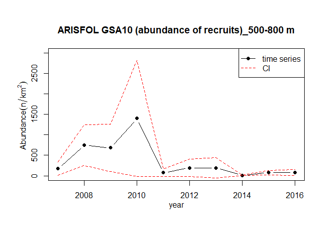
#>    year   abundance         sd
#> 1  2007  173.819218  85.441493
#> 2  2008  746.525103 253.963668
#> 3  2009  682.000011 295.301758
#> 4  2010 1399.952318 724.374171
#> 5  2011   73.869603  44.097009
#> 6  2012  193.791201 106.736291
#> 7  2013  194.214778 125.944553
#> 8  2014    7.068412   3.177105
#> 9  2015   75.946935  28.093725
#> 10 2016 77.475985 38.404432Placing the above described indices in the spatial dimension is very useful for several objectives, as the knowledge of the distribution and abundance of the species at local and regional spatial scale, the identification of areas with certain peculiarities, the localization of sensitive life stage of the population, etc… GFCM grid is considered as the better available trade-off for the spatial scale to be used in the different steps of the analysis, especially considering the subsequent possible overlap with maps of the fishing effort spatial distribution. This despite the fact that not any unit in the grid can actually encompass the spatial distribution of all the life stages of a given species, especially when this distribution is depth related. To perform the spatial analysis of the indicators it is needed to assign the haul information to the relative cells of the GFCM statistical grid contained in cgpmgrid variable as SpatialPolygonsDataFrame. The functions TATB.grid and TATC.grid were generated with this purpose:
# overlap of TATB with the grid
gTATB <- TATB.grid(TA,TB,"ARISFOL")

# overlap of TATC with the grid
gTATC <- TATC.grid(TA,TC,"ARISFOL")
The estimation of the indices over the statistical grid is performed by the function sp.index:
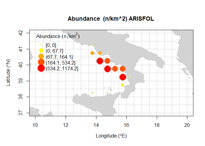
#>    cgpmgridlevel GSA   meanNkm2    sdNkm2    cvNkm2 inverse_cvNkm2 nhauls
#> 1           5091  10    0.00000    0.0000       NaN            NaN     20
#> 2           5227  10   99.99893  329.7339 3.2973739      0.3032716     60
#> 3           5228  10   81.62708  230.6419 2.8255557      0.3539127     20
#> 4           5229  10    0.00000    0.0000       NaN            NaN     11
#> 5           5364  10 1174.22674 1190.8150 1.0141270      0.9860698     20
#> 6           5365  10  180.12146  421.2692 2.3388063      0.4275685     99
#> 7           5501  10 1140.74609  928.8783 0.8142726      1.2280899     10
#> 8           5502  10  433.82575 1009.3968 2.3267333      0.4297871     57
#> 9           5503  10  479.51507 1678.8692 3.5011814      0.2856179     63
#> 10          5639  10  616.35084  626.4636 1.0164075      0.9838574     83
#> 11          5640  10    0.00000    0.0000       NaN            NaN     20
#> 12          5775  10   64.19004  121.4411 1.8919000      0.5285692      7
#> 13          5907  10    0.00000    0.0000       NaN            NaN     10
#> 14          5909  10    0.00000    0.0000       NaN            NaN     20
#>    positive_hauls   lon   lat
#> 1               0 13.75 41.25
#> 2              11 13.75 40.75
#> 3               4 14.25 40.75
#> 4               0 14.75 40.75
#> 5              20 14.25 40.25
#> 6              27 14.75 40.25
#> 7              10 14.75 39.75
#> 8              17 15.25 39.75
#> 9              13 15.75 39.75
#> 10             81 15.75 39.25
#> 11              0 16.25 39.25
#> 12              2 15.75 38.75
#> 13              0 13.75 38.25
#> 14              0 14.75 38.25
Furthermore, the function bubble.rs, using TA, TB, and TC tables estimates the abundance indices per hauls for recruits and spawners specimens. Recruits and spawners specimens are selected using the cutoff parameter defined by the user. Bathymetrical lines refers respectively to 50m, 200m, and 800m of depth.
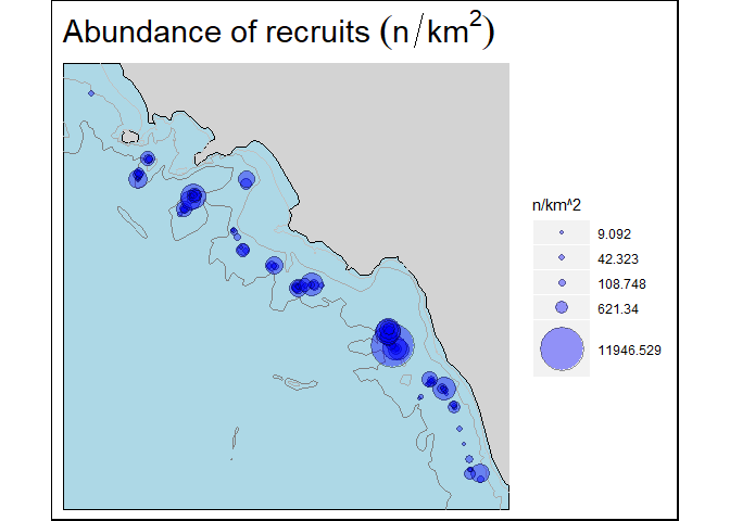
The different percentiles of a length frequency distribution (LFD) are expected to respond differently to fishing, recruitment pulses, and loss of spawning stock. It is assumed to be negatively (decrease) affected by an excessive fishing pressure.
Length frequency distribution (LFD) is computed by the LFD function, while the Lq is estimated by quant function:
merge_TATB <-  m.TATB(TA,TB,"ARISFOL")
merge_TATC <-  m.TATC(TA,TC,"ARISFOL")
indices <- index.ts(merge_TATB,GSA = 10 ,"ARISFOL",index = "abundance",
depth_range=c(500,800), str.scheme=strata_scheme,
surf=stratification_scheme, sampling = "RSS",plot=FALSE)
freq <- LFD(merge_TATC,indices,sex="m",LC=1,depth_range=c(500,800), type = "indices")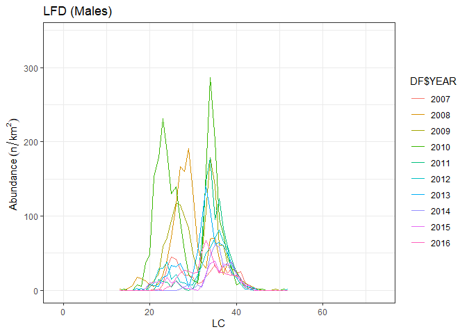
quant(freq,0.95)
#>             2007  2008  2009  2010  2011  2012  2013  2014  2015  2016
#> percentile 40.90 37.80 38.70 36.90 39.00 38.80 39.30 40.30 40.60 40.10
#> Variance 0.04 0.14 0.05 0.01 0.02 0.01 0.03 0.05 0.04 0.06In presence of a short trawl survey time series the significance of the trend can be estimated using nonparametric statistical tests as Spearman rho (Cotter, 2009). Spearman’s rho is the product-moment correlation between the ranks of paired data. The spearman.test function perform the Spearman test of the trend on the indices time series: